Файл:Cornelis anthonisz vogelvluchtkaart amsterdam.JPG
Памер прагляду: 616 × 599 піксэлаў. Іншыя разрозьненьні: 247 × 240 піксэлаў | 493 × 480 піксэлаў | 789 × 768 піксэлаў | 1052 × 1024 піксэлаў | 2231 × 2171 піксэлаў.
Арыгінальны файл (2231 × 2171 піксэль, памер файла: 1,7 Мб, тып MIME: image/jpeg)
|
|
Гэты файл паходзіць зь Вікісховішча. Зьвесткі пра гэты файл зь яго старонкі апісаньня прыведзеныя ніжэй. Вікісховішча — сховішча вольных мэдыяфайлаў. Вы можаце дапамагчы. |
Апісаньне
| Карнеліс Антоніс: Q116787851
|
|||||||||||||||||||||||||||||||||||||||||||||||
|---|---|---|---|---|---|---|---|---|---|---|---|---|---|---|---|---|---|---|---|---|---|---|---|---|---|---|---|---|---|---|---|---|---|---|---|---|---|---|---|---|---|---|---|---|---|---|---|
| Мастак |
|
 | |||||||||||||||||||||||||||||||||||||||||||||
| Назва |
нямецкая: Die berühmte Handelsstadt Amsterdam
нідэрляндзкая: De vermaerde koopstadt van Amstelredam
|
||||||||||||||||||||||||||||||||||||||||||||||
| Тып аб’екту | эстамп | ||||||||||||||||||||||||||||||||||||||||||||||
| Апісаньне |
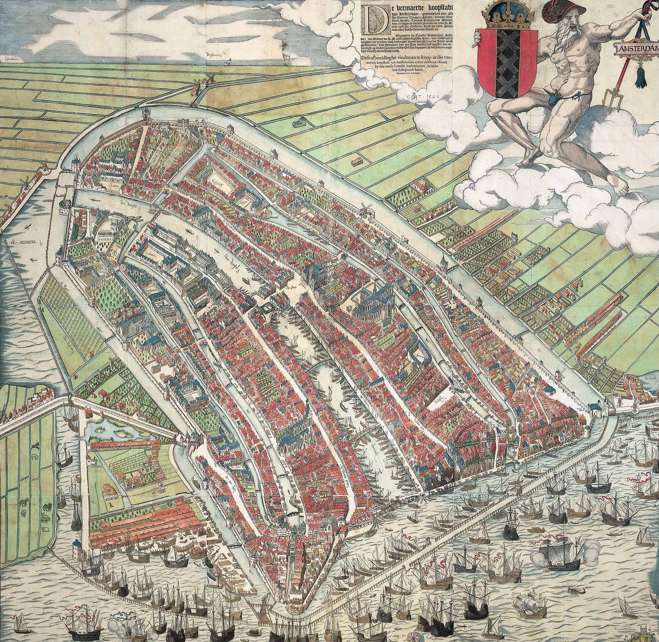
A bird's eye view of Amsterdam looking south. This is the city before the construction of the semi-circular ring of canals. It is bordered by the IJ, the Singel in the west, and the Kloveniersburgwal/Gelderse Kade in the east. The waterway in the middle (connecting the Dam with the IJ) is known as the Damrak. Ships were unloaded on the west bank of the Damrak, indicated on the map as ‘Opt Waeter’ (on the water). Woodcut by Cornelis Anthonisz. dated 1544. Fourth edition out of a total of six editions. This version is a reprint published by Ian Iansz. around 1557. |
||||||||||||||||||||||||||||||||||||||||||||||
| Дата | Каля 1557 | ||||||||||||||||||||||||||||||||||||||||||||||
| Тэхніка | woodcut print, brush and color | ||||||||||||||||||||||||||||||||||||||||||||||
| Разрозьненьне | вышыня: 107 см; шырыня: 109 см | ||||||||||||||||||||||||||||||||||||||||||||||
| Калекцыя |
|
||||||||||||||||||||||||||||||||||||||||||||||
| Асабісты нумар |
KOG-2684 (Royal Dutch Antiquarian Society) |
||||||||||||||||||||||||||||||||||||||||||||||
| Place of creation | Амстэрдам | ||||||||||||||||||||||||||||||||||||||||||||||
| Гісторыя аб’екту |
Невядомая дата: acquired by Koninklijk Oudheidkundig Genootschap, Inventory number KOG-2684, from jkvr. H.M.A.F. Six (?) Невядомая дата: lent to the Дзяржаўны музей, Амстэрдам, Amsterdam, by Koninklijk Oudheidkundig Genootschap (?) |
||||||||||||||||||||||||||||||||||||||||||||||
| Гісторыя выставак | Het Aanzien van Amsterdam. Panorama's, plattegronden en profielen uit de Gouden Eeuw, Stadsarchief Amsterdam, Амстэрдам, 19 кастрычніка 2007–16 студзеня 2008, ISBN 978-90-6868-444-5, p. 90-92, кат. no. 4, with color image, як Plattegrond van Amsterdam met de gebouwen in opstand, Amsterdam, Koninklijk Oudheidkundig Genootschap. | ||||||||||||||||||||||||||||||||||||||||||||||
| Надпісы |
Caption : De vermaerde koopstadt / van Amstelredam, gheconterfeyt met alle / sijn Wateren, Bruggen, Straten, kercken, kloo- / steren, Huysen, Toorens, Poorten ende Mueren, / ende omleggende situatie, gemaekt ter eeren K. M. / ende oock den Eersamen Raedt der selver Stadt, / ende alle Liefhebberen der Konste, etc. // Wtgegeven by Cornelis Anthonizoon Schil- / der, met Octroye der K. M. onsen ghenadighsten Heere van 't selfde niet te / moghen nae-drucken noch verkoopen binnen den tijdt van ses Jaren lanck / gheduerende, ende ghedateert van den Jare duysent vijf-honderd drie-en- / veertigh, op seeckere penen int selvde Octroye begrepen, op dat hem een yege- / lijck voor schade verhoede mach. // Dese afbeeldinghe vindtmen te koop in die ver- / maerde koopstadt van Amstelredam achter de Nieuwe Kerck / by den voorsz Cornelis Anthoniszoon, Schilder / inde Schrijvende handt. // ende nu by Ian Iansz, Print-drucker |
||||||||||||||||||||||||||||||||||||||||||||||
| Зацемкі | Van deze plattegrond zijn zes verschillende uitgaves bekend; uit 1544, 1544-1545, 1545-1553, ca. 1557, ca. 1557-1636 en 1636-1664. | ||||||||||||||||||||||||||||||||||||||||||||||
| Спасылкі | |||||||||||||||||||||||||||||||||||||||||||||||
| Крыніца | archive.org, cultuurwijzer.nl/nwc.gemeentearchiefamsterdam | ||||||||||||||||||||||||||||||||||||||||||||||
| Іншыя вэрсіі |
|
||||||||||||||||||||||||||||||||||||||||||||||
.jpg)


_by_Cornelis_Anthonisz.jpg)
| Зацемкі | Гэтая выява мае дадатковыя зацемкі: праглядзець у Вікісховішчы |


Ліцэнзія
|
Гэтая выява зьяўляецца дакладнай рэпрадукцыяй мастацкае працы. Сама праца знаходзіцца ў грамадзкім набытку па наступных прычынах:
Афіцыйная пазыцыя Фундацыі «Вікімэдыя» заключаецца ў тым, што «дакладныя рэпрадукцыі твораў, якія знаходзяцца ў грамадзкім набытку, самі па сабе зьяўляюцца грамадзкім набыткам, а ўсе спробы абмежаваць выкарыстаньне гэтага набытку зьяўляюцца прамым нападам на саму яго ідэю». Для даведкі глядзіце артыкул Калі карыстацца шаблёнам PD-Art.
Гэтая рэпрадукцыя таксама мусіць быць у грамадзкім набытку. Памятайце, што прававымі нормамі дзяражавы вашага месцазнаходжаньня паўторнае выкарыстаньне гэтае рэпрадукцыі можа быць забаронена. Глядзіце артыкул Паўторнае выкарыстаньне фатаздымкаў у PD-Art. | ||||
Гісторыя файла
Націсьніце на дату/час, каб паглядзець, як тады выглядаў файл.
| Дата і час | Мініятура | Памеры | Удзельнік | Камэнтар | |
|---|---|---|---|---|---|
| цяперашняя | 14:05, 11 красавіка 2008 | | 2231 × 2171 (1,7 Мб) | Vincent Steenberg | {{Information |Description={{en|Cornelis Anthonisz. ''Bird's eye view of Amsterdam.'' 1544. Woodcut.}} {{nl|Cornelis Anthonisz. ''Vogelvluchtkaart van Amsterdam.'' 1544. Houtsnede.}} |Source=http://www.cultuurwijzer.nl/nwc.gemeentearchiefamsterdam/cultuur |
Выкарыстаньне файла
Ніводная старонка не выкарыстоўвае гэты файл.
Глябальнае выкарыстаньне файла
Гэты файл выкарыстоўваецца ў наступных вікі:
- Выкарыстаньне ў ar.wikipedia.org
- Выкарыстаньне ў en.wikipedia.org
- Выкарыстаньне ў hy.wikipedia.org
- Выкарыстаньне ў nl.wikipedia.org
- Выкарыстаньне ў vi.wikipedia.org
- Выкарыстаньне ў www.wikidata.org
- Выкарыстаньне ў zh.wikipedia.org