Файл:Cape Town 2001 dominant language map.svg

Памер гэтага PNG-прагляду для SVG-файлу: 505 × 599 піксэлаў. Іншыя разрозьненьні: 202 × 240 піксэлаў | 404 × 480 піксэлаў | 647 × 768 піксэлаў | 863 × 1024 піксэлаў | 1726 × 2048 піксэлаў | 814 × 966 піксэлаў.
Арыгінальны файл (SVG-файл, намінальна 814 × 966 піксэлаў, памер файла: 1,48 Мб)
|
|
Гэты файл паходзіць зь Вікісховішча. Зьвесткі пра гэты файл зь яго старонкі апісаньня прыведзеныя ніжэй. Вікісховішча — сховішча вольных мэдыяфайлаў. Вы можаце дапамагчы. |
Апісаньне
| Апісаньне |
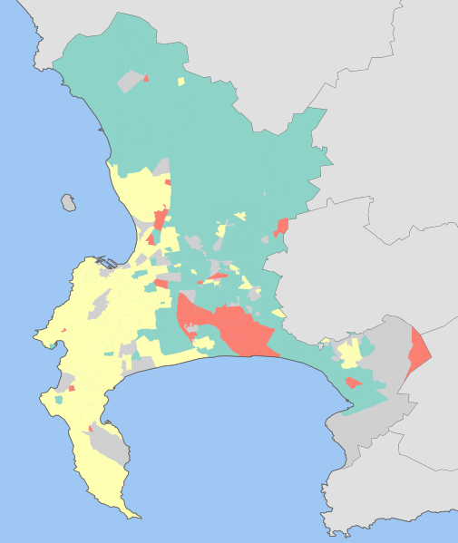
English: Map showing the dominant home languages in the City of Cape Town, Western Cape, South Africa, according to Census 2001 at the "Subplace" level. In this context, a language is dominant if it more than 50% of the population in an area speak it at home, or more than 33% speak it and no other language is spoken by more than 25%.
Afrikaans
English
isiXhosa
No language dominant |
| Дата | |
| Крыніца | Statistics South Africa's Census 2001 is the source of the basic population data. The map results from my own processing of the data. |
| Аўтар | Htonl |
Ліцэнзія
The following license applies to the population data on which the map is based:

|
Уладальнік аўтарскіх правоў на гэты файл, Stats SA, дазваляе ўсім выкарыстоўваць яго ў любых мэтах, пры ўмове, што уладальнік аўтарскіх правоў пазначаны належным чынам. Распаўсюджаньне, стварэньне вытворных прац, камэрцыйнай выкарыстаньне і іншыя выкарыстаньні дазволеныя. |
Пазначэньне аўтарства:
"the user acknowledges Stats SA as the source of the basic data wherever they process, apply, utilise, publish or distribute the data, and also that they specify that the relevant application and analysis (where applicable) result from their own processing of the data" [1]
|
The following tag applies to the map itself:
| Я, уладальнік аўтарскіх правоў на гэтую працу, перадаю яе ў грамадзкі набытак. Дазвол сапраўдны для ўсяго сьвету. У некаторых краінах гэта ня можа быць юрыдычна магчыма; калі так, то: Я дазваляю кожнаму выкарыстоўваць гэтую працу ў любых мэтах, без аніякіх умоваў, калі толькі такія ўмовы не патрабуюцца паводле закону. |
Гісторыя файла
Націсьніце на дату/час, каб паглядзець, як тады выглядаў файл.
| Дата і час | Мініятура | Памеры | Удзельнік | Камэнтар | |
|---|---|---|---|---|---|
| цяперашняя | 20:42, 16 лютага 2010 | | 814 × 966 (1,48 Мб) | Htonl | size |
| 00:17, 16 лютага 2010 |  | 842 × 1000 (1,46 Мб) | Htonl | tweak | |
| 19:17, 15 лютага 2010 |  | 842 × 1000 (1,37 Мб) | Htonl | =={{int:filedesc}}== {{Information |Description={{en|1=Map showing the dominant home languages in the City of Cape Town, Western Cape, South Africa, according to Census 2001 at the "Subplace" level. In this context, a language is dominant if it more than |
Выкарыстаньне файла
Наступная старонка выкарыстоўвае гэты файл:
Глябальнае выкарыстаньне файла
Гэты файл выкарыстоўваецца ў наступных вікі:
- Выкарыстаньне ў cy.wikipedia.org
- Выкарыстаньне ў gl.wikipedia.org